Mountain Stage to Cahernaman Trail


Start: Mountain Stage (V 6265 8900)
Finish: Cahernaman (V 5660 8520)
OS Map: No. 70, 78 & 83
The first 1km of this stage sees the Kerry Way follow a minor road which runs parallel the Ring of Kerry Road. The remains of an old coach road begins at the foot of Drung Hill and continues for the remaining 7km of this stage. The trail passes through a series of gates and the ruins of a small farming settlement.
The road begins to level out upon reaching 250m, allowing for a full appreciation of the surrounding views. Rossbeigh Hill, White Strand and Inch Beach are left behind and the wide expanse of the Dingle Peninsula can be seen across the northern horizon.
Around 150 metres below the trail are the remains of an old train line which was used by the Great Southern and Western Railway Company up until 1960. With a little scrutiny of the hillside, two of the tunnels can be spotted along the defunct line. After passing through a saddle between Drung Hill and a small unnamed peak, Gleensk Viaduct can be seen to the base of the valley.
Those wishing to stay the night in Gleensk (part of Kells), must follow the trail for a further 2½km until passing through the forest at Coomshanna. After exiting the forest, follow the tree-line down the hill for around 300m to meet the main forestry road. This leads down to beneath the Gleensk Viaduct.
The 1½km section of forest can become extremely water-logged at times, good boots for this section are essential. After leaving the forest, it is a further 2km to reach the road at Cahernaman. Views of solitary mountain, Knocknadobar, tower over the Ferta Valley below. The Kerry Way once again passes some ruins of a long-abandoned farmstead.
Having arrived at Cahernaman, the 2km road walk to the right comes off the Kerry Way and leads down to Kells.
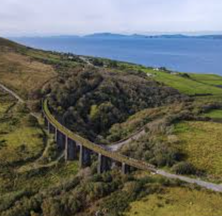
Overlooking the Gleensk Viaduct from the Kerry Way